Latitude, Longitude, and Time Complete Guide For Class 11 Geography Practical Chapter 3
Welcome to iPrep, your Learning Super App. Our learning resources for the chapter “Latitude, Longitude and Time” in Geography for Class 11th are designed to ensure that you grasp this concept with clarity and perfection. Whether you’re studying for an upcoming exam or strengthening your concepts, our engaging animated videos, practice questions, and notes offer the best of integrated learning with interesting explanations and examples.
This chapter explores the concepts of latitude and longitude, which form the basis of the Earth’s coordinate system. It discusses the drawing of parallels between latitude and meridians of longitude, the relationship between longitude and time, and the concept of the International Date Line.
Introduction:
Latitude and longitude are essential for locating any point on the Earth’s surface. These coordinates provide a precise system for identifying and navigating to different places. This chapter delves into the concepts of latitude and longitude, their measurement, and their significance in understanding the Earth’s geography.
Objectives:
Now that we have explored the importance of the chapter, let’s outline the objectives of studying it.
- To understand the concept of latitude and its measurement.
- To explore the concept of longitude and its measurement.
- To learn about the relationship between longitude and time.
- To understand the concept of the International Date Line.
Now let’s explore the various sections of the chapter.
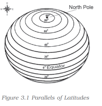
Finally, to understand the concept of latitude, let’s delve into the Parallels of Latitudes section of the chapter “Latitude, Longitude, and Time.”
Parallels of Latitudes
- Latitudes are imaginary lines running parallel to the Equator, horizontally across the globe.
- They are used to determine the distance north or south of the Equator.
- The Equator is the 0° latitude, while the North Pole and South Pole are at 90°N and 90°S, respectively.
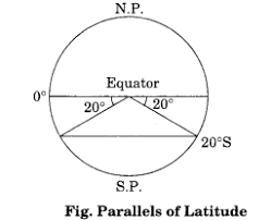
Now, to understand how to represent latitudes on maps, let’s explore the Drawing the Parallels of Latitudes section of the chapter “Latitude, Longitude, and Time.”
Drawing the Parallels of Latitudes
- Parallels of latitudes are drawn as concentric circles on maps, with the Equator being the largest circle.
- As one moves toward the poles, these circles get smaller.
- Each latitude is measured in degrees, with the Equator at 0° and the poles at 90°.
Now, in order to understand longitude, let’s delve into the Meridians of Longitude section of the chapter “Latitude, Longitude, and Time.”
Meridians of Longitude
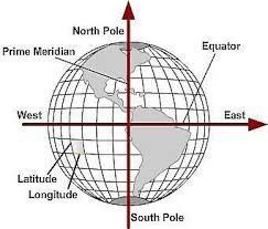
- Longitudes are imaginary lines that run from the North Pole to the South Pole, intersecting at both poles.
- The Prime Meridian, passing through Greenwich, England, is considered the 0° longitude.
- Longitudes are used to measure the distance east or west of the Prime Meridian, up to 180°.
Now, to understand how longitudes are drawn, let’s explore the Drawing the Meridians of Longitude section of the chapter “Latitude, Longitude, and Time.”
Drawing the Meridians of Longitude
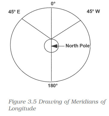
- Meridians of longitude are drawn as semi-circles stretching from pole to pole.
- The distance between meridians is greatest at the Equator and decreases toward the poles.
Now, in order to understand the relationship between longitude and time, let’s delve into the Longitude and Time section of the chapter “Latitude, Longitude, and Time.”
Longitude and Time
- The Earth’s rotation affects the calculation of time across different longitudes.
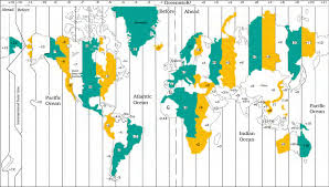
- Each degree of longitude represents a time difference of 4 minutes.
- Moving east of the Prime Meridian, time increases, while moving west, time decreases.
Now, in order to understand global time changes, let’s delve into the International Date Line section of the chapter “Latitude, Longitude, and Time.”
International Date Line
- The International Date Line is an imaginary line that runs approximately along the 180° meridian.
- It marks the boundary between one day and the next.
Finally, as we have gained comprehensive knowledge about the chapter “Latitude, Longitude, and Time”, let’s reflect on the overall learning value of this important lesson.
Overall Learning Value of the Chapter
The chapter “Latitude, Longitude, and Time” provides a foundational understanding of how the Earth’s grid system of latitudes and longitudes helps in determining exact locations on the globe. It also highlights the crucial relationship between longitude and time calculation, including the significance of the International Date Line in adjusting for global time differences. These concepts are essential for understanding the geographical coordination system, global navigation, and time zone management.
Let’s Conclude
In conclusion, the chapter “Latitude, Longitude, and Time” for Class 11th Geography has equipped you with a comprehensive understanding of the Earth’s coordinate system. Through this chapter, you’ve learned how latitude and longitude serve as essential tools for pinpointing exact locations on the Earth’s surface. The insights into how longitude relates to time and the significance of the International Date Line enrich your knowledge of global time zones and geographical coordination.
The interactive resources in the iPrep Learning Super App for the chapter “Latitude, Longitude, and Time” make mastering these concepts engaging and accessible. As you continue studying Geography for Class 11th, the foundational knowledge from “Latitude, Longitude, and Time” will enhance your grasp of spatial relationships, essential for interpreting maps, navigating locations, and understanding time differences around the world.
Practice questions on Chapter 3 - Latitude, Longitude, and Time
Get your free Chapter 3 - Latitude, Longitude, and Time practice quiz of 20+ questions & detailed solutions
Practice Now


