Map Projections – Complete Guide For Class 11 Geography Practical Chapter 4

Welcome to iPrep, your Learning Super App. Our learning resources for the chapter “Map Projections” in Geography for Class 11th are designed to ensure that you grasp this concept with clarity and perfection. Whether you’re studying for an upcoming exam or strengthening your concepts, our engaging animated videos, practice questions, and notes offer the best of integrated learning with interesting explanations and examples.
The chapter “Map Projections” introduces the concept of projecting the 3D surface of the Earth onto a 2D map. It explains the need for map projections and their various types, highlighting the challenges of accurately representing the Earth’s curved surface. The chapter further discusses the techniques for creating projections, different types of map projections, and specific examples like conical, cylindrical, and Mercator projection.
“Map Projections” is the first chapter of Class 11 Geography, focusing on how the Earth’s three-dimensional curved surface can be represented on a flat map. Since no projection can preserve all geographical features like distance, shape, and area simultaneously, the chapter discusses the various types of projections used for different purposes. By understanding these projections, students can learn how maps are drawn to represent different aspects of the Earth’s surface.
Objectives of Learning The Chapter – Map Projections
Now that we have explored the importance of the chapter, let’s outline the objectives of studying it.
- To understand the concept and purpose of map projections.
- To explore the different elements and properties involved in creating projections.
- To classify map projections based on techniques and surface types.
- To study specific projections, including the Conical, Cylindrical, and Mercator’s projections.
Now, to understand the basic concept, let’s delve into the Map Projection section of the chapter “Map Projections.”
Map Projection
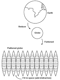
- A map projection is a method used to represent the Earth’s 3D surface on a 2D plane.
- Every projection has some distortion because the Earth is spherical, and a flat map cannot perfectly represent its features.
- Projections can prioritize the accuracy of certain features like distance, shape, or area, but not all simultaneously.
Now, to understand the reasons behind using projections, let’s explore the Need for Map Projection section of the chapter “Map Projections.”
Need for Map Projection
- Map projections are essential for translating the Earth’s curved surface onto flat maps for navigation, geographical study, and cartography.
- Different types of projections are used depending on the purpose—whether for preserving area (equal-area projections), shape (conformal projections), or distance (equidistant projections).


Now, in order to understand the components involved, let’s delve into the Elements of Map Projection section of the chapter “Map Projections.”
Elements of Map Projection
Reduced Earth
- This refers to representing the Earth as a small, proportional model, typically a globe, before projecting it onto a flat surface.
Parallels of Latitude
- Imaginary lines that run horizontally across the Earth. These are used as reference points for projections.
Meridians of Longitude
- Vertical lines that converge at the poles and run through the Earth’s surface, also serving as reference points for projections.
Global Property
- Each projection attempts to preserve specific global properties, such as shape, area, or direction.
Now, in order to understand how projections are categorized, let’s delve into the Classification of Map Projections section of the chapter “Map Projections.”
Classification of Map Projections
Drawing Techniques
- The techniques used to draw a map vary based on what is to be preserved—area, shape, or direction.
Developable Surface
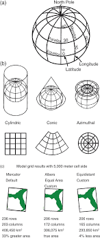
- Map projections are drawn by projecting the Earth’s surface onto a flat surface, which can be cylindrical, conical, or planar.
Global Properties
- Projections can be classified based on the properties they preserve, such as equal-area projections (preserving area) or conformal projections (preserving shape).
Source of Light
- The source of light can be at the center of the globe (gnomonic projection), on the surface (stereographic projection), or at infinity (orthographic projection).

Now, in order to understand how specific projections are constructed, let’s delve into the Constructing Some Selected Projections section of the chapter “Map Projections.”
Constructing Some Selected Projections
Conical Projection with One Standard Parallel
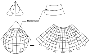
- This projection involves projecting the Earth’s surface onto a cone with one standard parallel, meaning the cone touches the Earth along one latitude.
Cylindrical Equal Area Projection
- In this projection, the Earth’s surface is projected onto a cylinder. The cylindrical equal-area projection preserves area but distorts shape near the poles.
Mercator’s Projection
- One of the most widely used projections, Mercator’s projection preserves direction, making it useful for navigation, but distorts areas near the poles.
Finally, as we have gained comprehensive knowledge about the chapter “Map Projections”, let’s reflect on the overall learning value of this important lesson.
Overall Learning Value of the Chapter
The chapter “Map Projections” provides valuable insights into how cartographers transform the Earth’s curved surface into flat maps through various projection techniques. It highlights the importance of understanding the different elements and types of projections, as well as the trade-offs involved in preserving certain global properties. By studying different projection types like conical, cylindrical, and Mercator’s projections, students gain a clearer understanding of how geographical features are represented on maps. This knowledge is crucial for both geography students and professionals in fields like navigation and cartography.
Let’s Conclude
In conclusion, the chapter “Map Projections” for Class 11 Geography provides students with a fundamental understanding of how Earth’s three-dimensional surface can be represented on a two-dimensional map. By studying “Map Projections,” students learn about the challenges involved in accurately portraying the Earth’s shape, distance, area, and direction on flat surfaces. This chapter “Map Projections” delves into various projection techniques like conical, cylindrical, and Mercator’s projections, each serving unique purposes in cartography and geography. With this knowledge, students of Class 11 can develop a solid foundation in map reading and construction, essential skills for advanced geographical studies, and real-world applications in navigation, exploration, and environmental planning.
Practice questions on Chapter 4 - Map Projections
Get your free Chapter 4 - Map Projections practice quiz of 20+ questions & detailed solutions
Practice Now


